

FIND YOUR WAY / BLUEWOOD
Plan the drive. Find your next line.
We’ll see you on the mountain.
THE DRIVE IS PART OF THE DAY.
Choose a starting city to see the miles and an estimated drive time. Explore the region, then open directions when you’re ready to roll.
WASHINGTON / TO BLUEWOOD
Final approach via Dayton, WA
| Starting city | State | Approx. miles | Est. drive time |
|---|---|---|---|
| Colfax | WA | 91 | 1 hr 45 min |
| Dayton | WA | 21 | 30 min |
| Moses Lake | WA | 140 | 2 hr 30 min |
| Pomeroy | WA | 54 | 1 hr 15 min |
| Pullman | WA | 108 | 2 hr |
| Seattle | WA | 290 | 5 hr |
| Spokane | WA | 150 | 2 hr 45 min |
| Tacoma | WA | 305 | 5 hr 30 min |
| Tri-Cities | WA | 83 | 1 hr 45 min |
| Walla Walla | WA | 52 | 1 hr 15 min |
| Yakima | WA | 165 | 3 hr |
| Bend | OR | 320 | 6 hr |
| Hermiston | OR | 106 | 2 hr |
| La Grande | OR | 150 | 2 hr 45 min |
| Pendleton | OR | 95 | 1 hr 45 min |
| Portland | OR | 295 | 5 hr 15 min |
| Boise | ID | 305 | 5 hr 15 min |
| Coeur d’Alene | ID | 180 | 3 hr 15 min |
| Lewiston | ID | 94 | 1 hr 45 min |
| Moscow | ID | 117 | 2 hr 15 min |
| Billings | MT | 690 | 11 hr 45 min |
| Bozeman | MT | 550 | 9 hr 30 min |
| Butte | MT | 465 | 8 hr |
| Great Falls | MT | 515 | 8 hr 45 min |
| Helena | MT | 460 | 8 hr |
| Kalispell | MT | 390 | 6 hr 45 min |
| Missoula | MT | 350 | 6 hr |
Approximate planning values, not live navigation or guaranteed fastest routes. Montana estimates use a planning route via Spokane and Dayton. Allow extra time for snow, traffic, stops, and changing road conditions. Check current directions before leaving.
FIND YOUR NEXT LINE.
Zoom in on the runs, lifts, and spots you want to check out. Expand the map for a closer look, then reset to see the whole mountain.
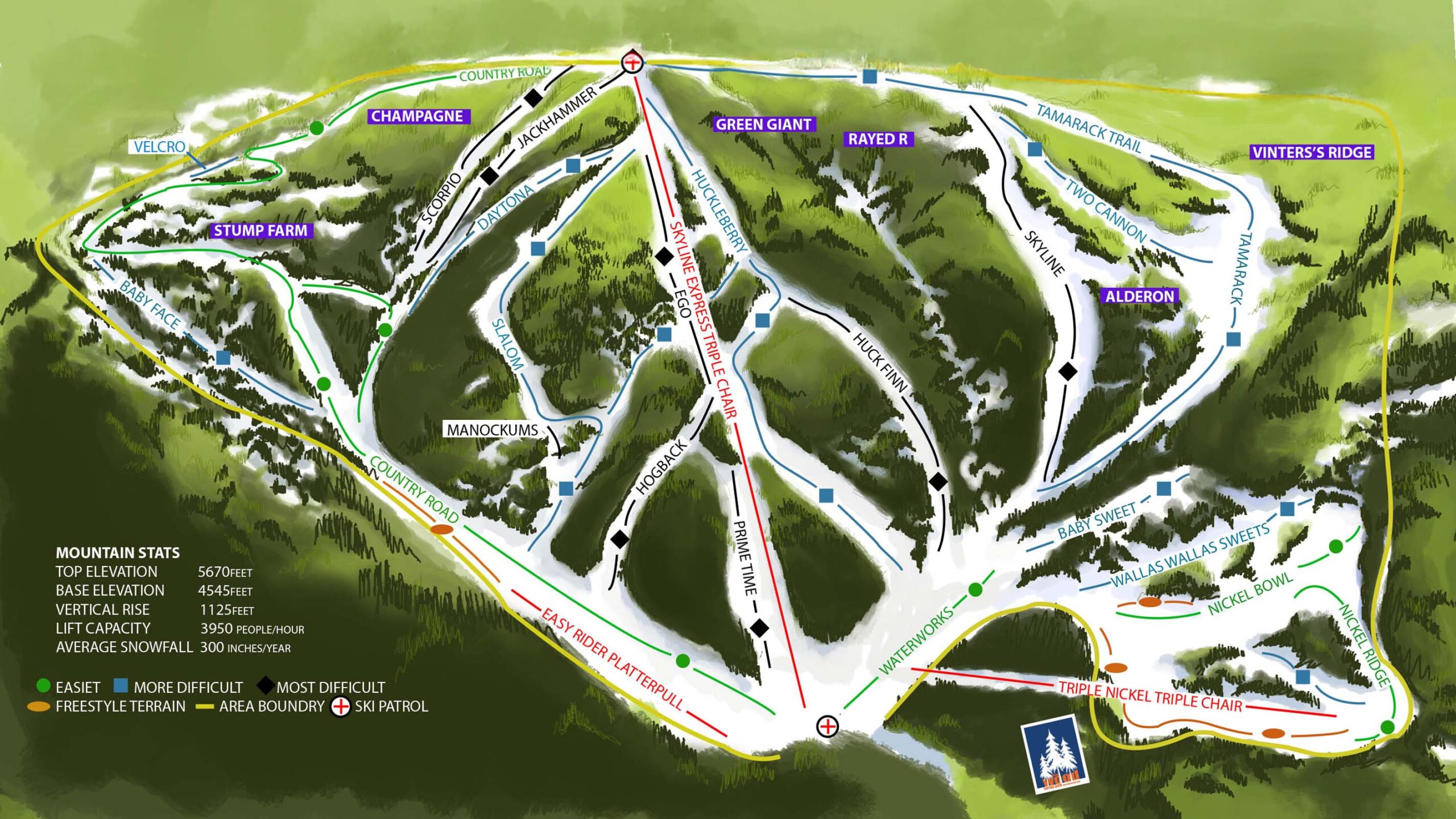
Named runs on the trail map
Named runs on the trail map
Named runs on the trail map
20+ feet of annual snowfall / 400+ acres of rideable terrain
For today’s report, check conditions →
THE LAST STRETCH.
Bluewood is about 21 miles from Dayton, tucked into the Blue Mountains. Set your destination to Bluewood and approach from Dayton on North Touchet Road.
Before leaving, check the operating calendar, mountain report, and road conditions. Give yourself extra time when winter weather moves in.
2000 N. Touchet Rd.
Dayton, WA 99328
Check the latest mountain report and make sure we’re on the operating calendar for your visit.
Find your way around the parking areas, or look into staying the night at the mountain.
Get the lay of the land before you arrive. Our overview brings the mountain basics together in one place.
A FEW GOOD PLACES TO START.
Tickets, gear, and the details for your next mountain day.